Hennepin Canal Bridge

Posted March 21, 2010 by BG
Categories: Uncategorized

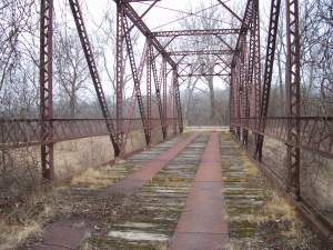
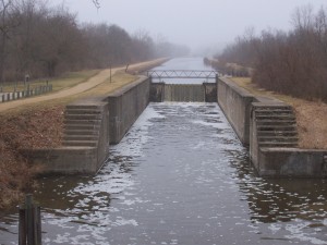
Work took me to the Hennepin Canal the other day, and I came across this old bridge still in use (bypassed in 2002) for foot traffic across the canal.

The bridge dates from 1900 according to the bridge plates left by the manufacturer on both sides of the bridge.

It is safe to cross (unlike a bridge crossing Bureau Creek further east, that’ll be another post).

Bureau County even left up the old weight limit signs when they bypassed this section of road.

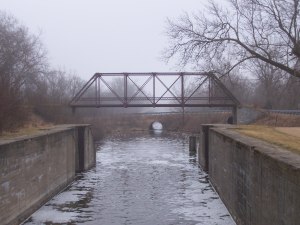
The bridge is a great place to view the old lock along the canal.

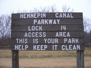
There’s even a small park to go along with it.

Lament for Jefferson Square

Posted March 11, 2010 by BG
Categories: Uncategorized

Jefferson Square was a mall I knew well while growing up.  It was a simple two anchor mall, with Montgomery Ward on the west end and Wieboldt’s on the east end.  Opened in 1975, it was Joliet, Illinois’s first indoor mall.  The mall had some major competition in 1978 when the Louis Joliet Mall opened a few miles away, but it held its own until Wieboldt’s closed in 1987.  Then it started to lose stores and go into a downward spiral.  In 1992, Menards took over the former Wieboldt’s, but the entry to the mall was sealed off.  In 1996, the mall was remodeled and became “Wilderness Mall”.  Unfortunately, this had the side effect of pushing out some of the remaining chain stores.  Then Montgomery Ward closed in 2001.  Menards bought the mall a few years later, and then tore it down in 2006, starting with the former Ward’s.  Currently, a Menards and a Wal Mart Supercenter occupy the site.  Here’s an image from the golden days, and a mall map from 1990 or so.

This was the north wing.  Note the sunken seating area.  The mall had four of these, one in each wing.

A Few Upper Peninsula Signs and Sights

Posted March 9, 2010 by BG
Categories: Uncategorized

Just a few signs and sights from the Upper Peninsula that I took back in the late 1990s.

Business US-41 in Marquette, Michigan.  Today, it has been decommissioned, but at one time it went though downtown Marquette.  Notice how the Business US-41 shield is not exactly typical.

M-203’s beginning in Hancock, Michigan, taken from northbound US-41.  US-41, of course, has the destinations of Calumet, and the ultimate destination for US-41, Copper Harbor.  M-203 gets a state park.

Another view of the intersection.  Note the internally illuminated stop and turn signs above the intersection.

Indiana Toll Road pictures

Posted December 5, 2009 by BG
Categories: Indiana, Toll Road

My first real post on this blog.  I’ll post from time to time and intermittently, but I will have something interesting for all to see.

Our first stop is the Indiana Toll Road.  Originally built in the mid 1950s, these photographs are from a brochure about the Toll Road published not long after the road was built.

The Sign of Pleasant Motoring, the Indiana East-West Toll Road. This is the cover of the brochure showing the Toll Road at the Gary West Interchange, at the time, Exit 1A (later Exit 2, then Exit 13, now Exit 14A).

The top is the Toll Road in St Joseph County, and the bottom is the Toll Road at the Gary East Interchange, at the time, Exit 2 (later Exit 17). The speed limits according to the brochure were 65 mph for cars and 55 mph for trucks. Now, the Toll Road east of the Willowcreek Barrier is 70 mph for cars and 65 mph for trucks. How times have changed.

The Toll Road passing through the Michigan City Interchange, at the time, Exit 3 (later Exit 39). The Toll Road has not changed much since the 1950s in this section. In fact, the major changes have been the elimination of three sets of snack bars and gas stations (Service Areas 2, 4, and 6), and the addition of several interchanges. Currently, the Toll Road is undergoing its most major changes yet in Lake County, the addition of a third lane in each direction.

The Toll Road at the LaPorte Interchange, at the time, Exit 4 (later Exit 49). The scene has not changed much since the 1950s here.

We’ll leave the Toll Road where we began, in Lake County. This is the Hammond Interchange, aka the Westpoint Barrier, at the time, Exit 1 (later Exit 5). The Westpoint Barrier was where one left the ticket system and went east to Exit 0 and the Calumet (now Chicago) Skyway Toll Bridge. Note the original signage for the Toll Road in the photograph. Straight ahead is “Chicago and West”, and the exit is for “Hammond, US-41” (with US-41 in a shield).

Hello world!

Posted December 3, 2009 by BG
Categories: Uncategorized

Welcome to WordPress.com. This is your first post. Edit or delete it and start blogging!